Outlook for December 2016
Outlook for December 2016
Published : 25-Nov-2016 10:33
Some of you have noticed the long-range snow forecasts (for the first half of December) have been somewhat dynamic recently; one day forecasting lots of snow, then little, etc.I've also had an email asking if it's going to be really mild in December... So here are some thoughts... 8)
First off, remember that forecasting snow amounts for more than a week ahead really is fraught with challenge. It crops up regularly but always worth remembering that some of the biggest snowfalls occur along the boundaries (fronts) between weather systems - the classic scenario being warm, moist air from the South meets icy cold air from the North over the mountains (bingo!). We talk of bands of snow along these boundaries; mobile bands of snow give us lighter snow over a wider area, slow moving (or even stationary) bands of snow can give huge but quite localized falls.
So the exact tracks of the major weather systems is what matters for us; if they vary just a little then the snow forecast for a particular location can change completely (from huge snow to no snow and vice versa).
Right now, the forecast models are juggling conflicting outcomes driven by numerous factors including a weak Polar Vortex, the vagaries of the Jetstream, and the possible development and/or collapse of arctic blocking.
A good illustration of the model uncertainty can be seen in the current GFS ensemble chart for Geneva included below.
The various lines are model runs with slight changes in input parameters.
- You can see they're all consistent until the end of November - so we can have a high level of confidence that the average of those runs is a pretty good forecast.
- But they scatter at the beginning of December - telling us there's very low confidence in any one of those outcomes being correct. One of them will likely be close to reality, but we don't know which.
FWIW, it does look as if December's going to bring plenty of snow (lower set of lines), but the rain/snow line is unclear at the moment.
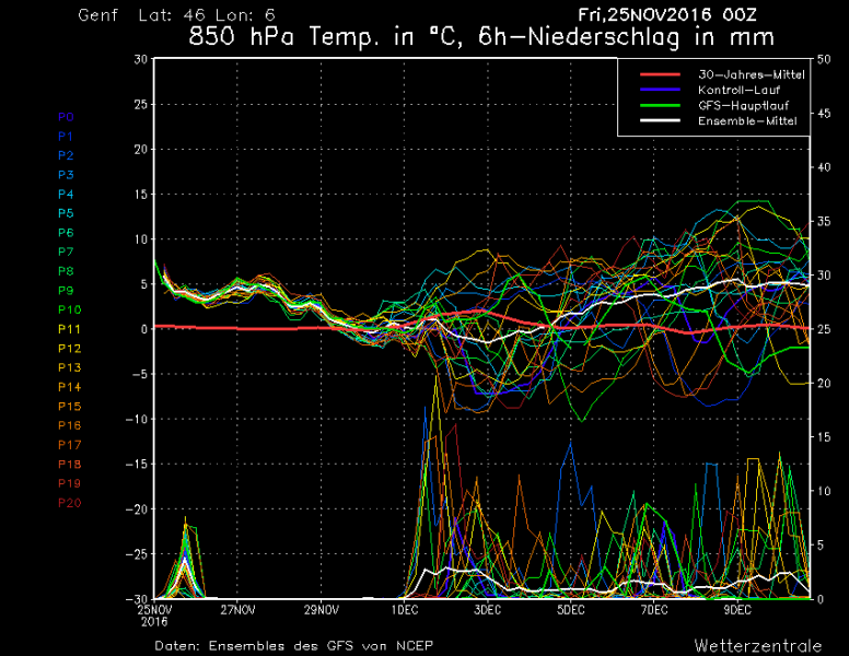
One other point to remember :- there are various "temperature anomaly" charts available; in general, these show you the difference between the forecast temperature and the seasonal average temperature. Even if they indicate a +2C anomaly, that just means 2C milder than the seasonal average... so still pretty cold in December!
Similarly, although you can see the average temperature predicted by the ensemble above (the upper white line) is around 5C at the end of December; that is in Geneva which is 1,000m below where you'll be skiing! 8)
I'll update this thread as the December forecast becomes clearer, but it looks promising from here.
References
If you want more (about the Polar Vortex and Arctic Oscillation), there's good in-depth coverage here https://www.aer.com/science-research/climate-weather/arctic-oscillation
Join the conversation : Discuss this in the J2Ski Forum (14 comments so far)
This news item has been viewed 17,857 times.