J2Ski Snow Report - January 30th 2025
J2Ski Snow Report - January 30th 2025
Published : 30-Jan-2025 21:32
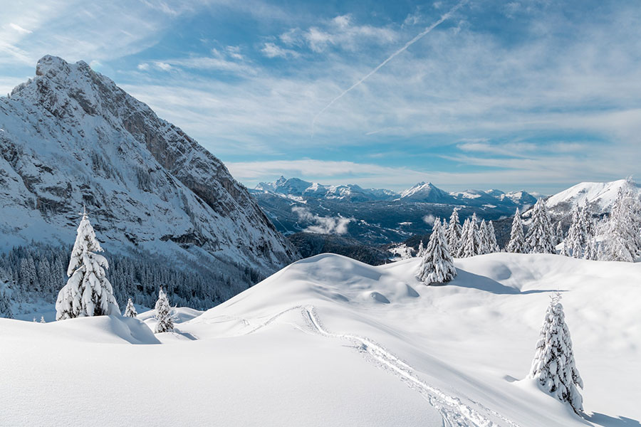
Samoens, Grand Massif, France, looking lovely under fresh snow...
Decent snowfalls across much of Europe and Scandinavia. Major falls expected for USA (Pacific) and Japan.
The Snow Headlines - January 30th
- Very heavy snowfall in the Alps - up to 60cm in 24 hours, 120cm in 72 hours.
- The heaviest snowfall of the season to date in Scandinavia.
- Huge snowfalls forecast for US Pacific Coast this weekend.
- Scottish centres have some of the best conditions of 24-25 so far.
- Midsummer snowfalls in New Zealand.
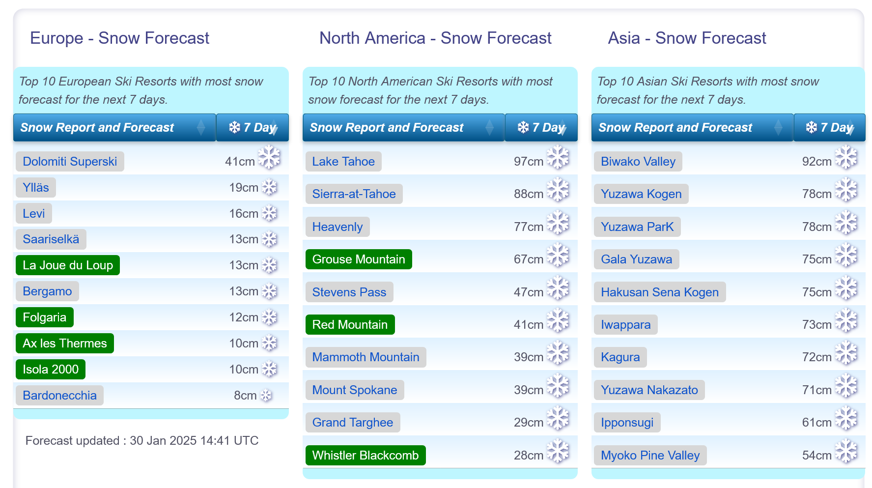
Snow forecasts worldwide.
Re-publication :- the J2Ski Snow Report Summary, being the text above this line, is free to re-publish, but must be clearly credited to www.J2ski.com with text including "J2Ski Snow Report" linked to this page - thank you.
World Overview
There's been a big change in the weather in the Alps this week with heavy snowfall moving in across much of the region, sending bases back on an upward trajectory after weeks of not a lot happening.
It's not just the Alps either, the Pyrenees have seen some of their best snowfalls of the winter and up in Scandinavia its back to cold and snowy weather too, again with some of the biggest accumulations of the season to date. Even Scottish centres have been able to re-open slopes requiring natural cover after conditions improved here too.
Please Take Care! The current snowpack in the Alps, over a wide area, has "weak layers" off-piste following the latest snowfall, and there have been a number of fatalities in avalanches this past week. Check the regional and local Avalanche Bulletins/Reports before leaving the piste, always take safety kit (and know how to use it) and do not ski alone.
Over in North America, it has been cold again, just not so cold as the week before. As previously there have been some modest snowfalls but nothing to get over excited about. On the upside, most centres remain fully open with the most terrain they've had available all winter. There's also something big coming this weekend with colossal snowfalls expected on America's Pacific coast.
Japan continues to top the world snow depths league although here too there's been much drier weather this week. Several centres there have over 4m of snow lying and here too there's a big snowfall expected at the weekend, so 5 metres may be reached soon.
For a bit of novelty, the past week also saw some snowfall in New Zealand, where it is currently Midsummer and six months away from the season start. Mt Hutt was among the areas that saw their slopes turn white.
Europe
Austria
Austria has had a very snowy few days midweek, but the sunshine is now returning so skiers can enjoy all the fresh cover under blue skies.
Most centres have had 1-2 feet of fresh snow, although many saw rainfall on Tuesday as the storm moved in before this turned to snow.
Competitive focus is currently on Austrian resorts after the Kitzbuhel Hahnenkamm last weekend, the Schladming might slalom midweek and the 2025 FIS Alpine Skiing World Championships at Saalbach Hinterglemm starting next week. Each of these areas, like most Austrian resorts, is fully open with fresh snow.
France
It's been an amazing week for snowfall in the French Alps with the largest falls of the season so far.
Chamonix topped the tables with a 1.2m (4 feet) accumulation reported in 72 hours. It's posting the deepest base in the continent up at the top of the Valle Blanche at 3.9 metres (13 feet).
However, Avoriaz and Les Arcs both went through the 3 metres/10 feet base mark too.
The news wasn't 100% positive though, some areas, particularly lower slopes, saw torrential rain at the start of the storm and avalanche danger levels are well up (widely Level 3 - Considerable - and Level 4).
Bases are looking good for the rest of the season now plus the sun is back out this weekend too.
Italy
There was palpable relief in Italy, which has had little snowfall except along its northern and western borders all winter, as the country received some huge snow dumps this week.
Livigno's base depth, which had been very meagre, more than doubled and it was a similar story in many other Italian areas. The biggest gainers include Val Gardena, getting 70cm and La Thuile reporting 80cm.
As elsewhere, the sunshine is now returning and conditions are looking ideal for the coming week.
Switzerland
Switzerland has also had its share of huge snowfalls with Crans Montana posting the most, 70cm, although the Aletsch Arena was only slightly behind.
As elsewhere in the Alps, the snowfall led to a big jump in snow depths, particularly on higher slopes and most notable in the east of the country (where snowfall had been scant up to this week) for resorts like Arosa and St Moriz, both of which scored 50cm+.
The snow clouds are moving on here too and most of Switzerland will have a sunny weekend.
Scandinavia
It's been a good week for Scandinavia as conditions have continued to improve after the mid-January warm temperature blip.
Ski areas in Norway and Sweden reported some good snowfall accumulations of 20-40cm, the biggest of the season, at the weekend after stormy weather blew through, and the snow has kept falling since.
Sweden's Sälen, the country's largest resort by uplift, has been one of the big winners, reporting 50cm of snowfall this week and jumping from about 60% to 95% open. It was by no means alone with a much-improved picture across the region.
Pyrenees and Spain
This time last week forecasting models suggested that the Pyrenees, which are badly in need of a big dump, were due to get just that with similar accumulations to the Alps. Unfortunately, that failed to materialise and accumulations were in the low inches rather than several feet. Some centres saw rain too.
So the result hasn't changed much, most areas are still 50-70% open as they have been the past 4-6 weeks.
The good news is that more significant snowfall has rolled in to end the week which should bring a good refresh.
Heavy snowfall has been reported as far south as Sierra Nevada, Europe's most southerly resort.
Scotland
Scottish ski areas are looking better as temperatures have dropped and snow is falling once more.
Storm Éowyn was the catalyst for the change with violent gales and snow bringing blizzard conditions closing all centres at the end of last week. By Saturday it became clear that some areas had had snowfall blasted off it by the violent winds, others had drifts up to a metre deep.
Glencoe was the first to report it was opening terrain with natural cover last Sunday and all the other centres, except currently-closed Nevis Range, have been able to open some runs too. The only hiccup now is warming temperatures on the horizon.
Eastern Europe
It's been a mostly sunny week in the Balkans with rather warm temperatures, as high as +11C, at resort base levels, although Bansko has maintained its run back to its base and it is now getting colder with snow forecast.
Further north in the Tatras it has been colder with some snowfalls, if not so much as in the Alps to the south and west.
North America
Canada
Canadian ski areas have had another cold and rather dry week with just modest snowfalls on the eastern and western sides of the country.
That is set to change in the coming week with heavy snowfall forecast for coastal British Columbia, some of which should make it inland.
Temperatures have been in the -5 to -20C range and that's set to remain the case into the start of February.
On the eastern side of the country ski areas in Ontario are posting good cover thanks to Lake Effect snow and the largest centre, Quebec's Mont Tremblant, reports everything open and claims conditions are the best they've been all season.
USA
The US has had another cold week, if not quite so cold as the exceptionally cold week before when the snowfall made it to Florida.
There's not been much fresh snow this week, although upstate New York has had about a foot more and California also got similar totals, the most for a month or so.
Despite the lack of fresh cover conditions remain the best they've been all winter on the groomed runs at least with most centres fully open, or nearly so.
Things are set to change from this weekend in the west with big snowfalls expected, particularly in California, where current models suggest 2-3 metres of snow may arrive by this time next week. The snowfall should also continue further east to at least the northern Rockies.
Join the conversation : Discuss this in the J2Ski Forum
This news item has been viewed 6,412 times.
Also on J2Ski :- Les Arcs Snow Forecast Ski Hotels Ski Hire Ski Holidays